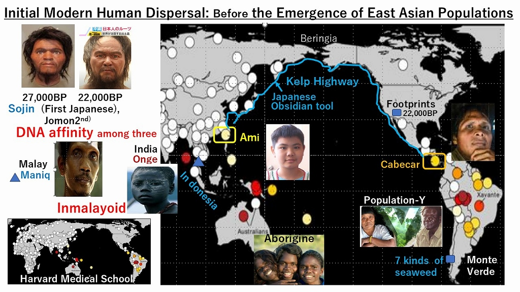
1.The genetic affinity between southern Australasians (Aborigines) and Amazonian tribes suggests that human dispersal followed a clockwise coastal route, as Harvard ‘s discovery and evidenced by fossil “footprints” .
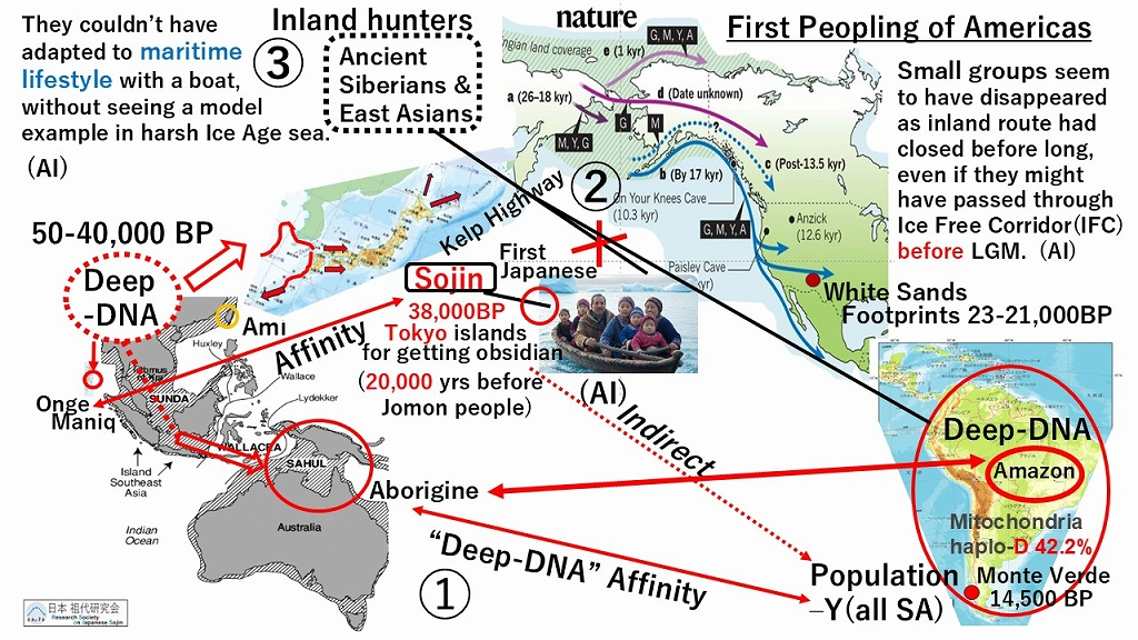
2.It is crucial that neither Tianyuan man nor the “Ancestral/Sojin” lineages (ancestors of the Jomon people, related to the Onge)—both belonging to the Basal East Asian (BEA) wave—have been discovered in North America; they were likely overwritten and erased by the subsequent influx of the Siberian Mal’ta lineage.
3.Since the Siberian ANA (Ancient Northeast Asians) could not have transitioned into a maritime population, the ancient South American Population- Y is theoretically most likely derived from the Japanese ” Sojin” lineages migrating southward along the coast.
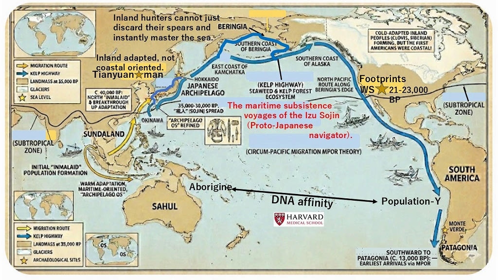
Inland big-game hunters cannot just drop their mega-spears and instantly “evolve” into master mariners to settle the Americas. It’s an evolutionary impossibility! The true pioneers? The 38k-year-old Izu Sojin with their advanced “Archipelago OS.”
🧠 Paradigm Shift: The Evolutionary Impossibility of the Western Migration Model “The conventional ‘Siberian-centric’ paradigm is untenable. The population in question represented an inland terrestrial lineage, entirely distinct from maritime cultures. The hypothesis that inland big-game hunters could abruptly abandon their specialized lithic weaponry to adopt an advanced coastal lifestyle is evolutionarily implausible. Rather, the primary candidates for this early migration are the Izu Sojin lineage of 38,000 BP, who carried the crucial ‘Archipelago OS’ required for open-ocean navigation.”
Let’s look at the actual technological compatibility.
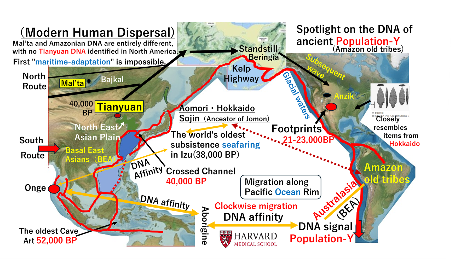
There is a prevailing misconception in Western academia that because the “Coastal Route” to the Americas is gaining traction, early modern humans like Tianyuan Man must have been coastal navigators who directly contributed to the southern Beringian maritime migration.
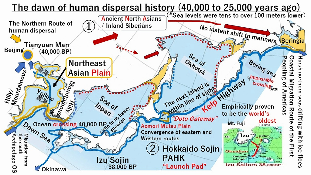
However, paleogeographic reconstructions from 40,000 to 25,000 years ago completely refute this. During this period, sea levels were tens to over 100 meters lower than today. What we now call the Bohai Sea and the Yellow Sea did not exist; they formed the vast, exposed Northeast Asian Plain. Consequently, the Tianyuan Cave site near Beijing was not a coastal area, but located deep within the inland hilly and mountainous terrain. Tianyuan Man was an inland population, though genetically similar to the maritime groups that later utilized the northern coastal highways.
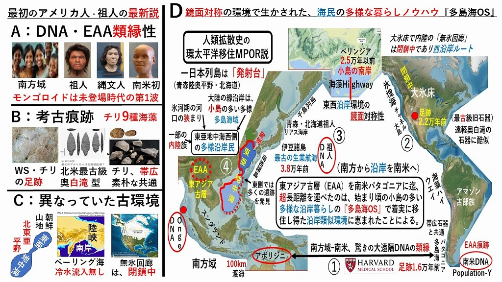
True maritime adaptation developed further east and north along the chain of islands—including Hokkaido, the Kuril Islands, relying on island-hopping where the next island was within line of sight—stretching toward the southern coast of Beringia. This Northern Pacific Kelp Highway Route of human dispersal involved seafaring starting, driven by populations expanding northward from the Southeast Asia and ocean crossing to Northern Kyusyu 40,000 years ago, eventually leading to a convergence of eastern and western routes at the Aomori Mutsu Plain. After the Launch Pad of Aomori/Hokkaido PAHK, they had navigated a harsh northern sea drifting with ice floes and migrated into Amazon and Patagonia. Therefore, conflating inland populations like Tianyuan Man with the specialized maritime innovators of the Paleo-Asian coastal route misinterprets both the Asian paleo-environment and the true history of human dispersal.
Published by: Research Society of Japanese Sodai (RSoJS) | Contact: sunda-wind.net
Executive Summary
Global academic discourse regarding the “First Americans” remains bottlenecked by a Eurocentric, Siberian-centric paradigm that overemphasizes the inland Mammoth Hunter lineage (Ancient North Eurasian / ANA) and the Clovis-First model. Furthermore, Western understanding of Japan’s deep past rarely looks beyond the Jomon period (approx. 16,500 years ago).
This report presents a disruptive, multi-wave migration framework proving that the true pioneers of the New World were maritime populations originating from the Japanese Paleolithic—the Sodai (祖代) / Sojin (祖人) era—who utilized the Kelp Highway via a unique Migration along Pacific Ocean Rim (MPOR).
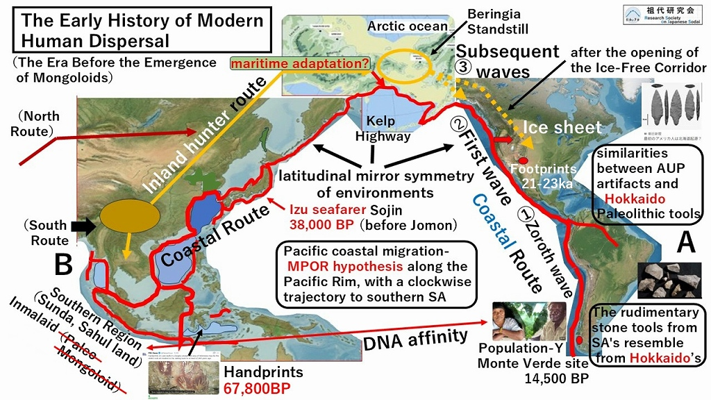
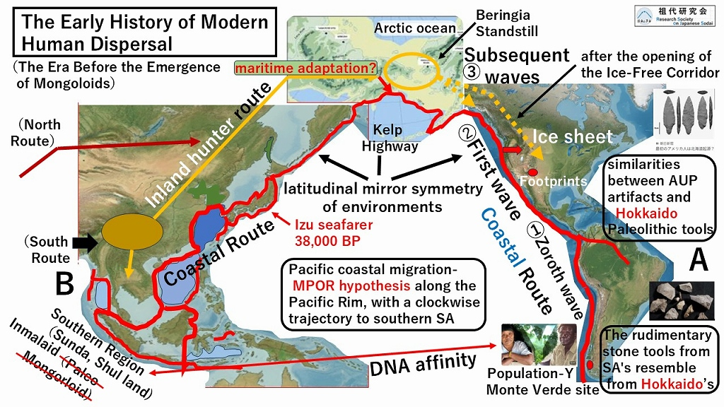
1. The Three-Wave Stratified Migration Framework
The initial peopling of the Americas cannot be attributed to a single, monolithic inland migration. Archaeological and technological typologies dictate a clear three-stage stratification:
[Wave 0: Zero Wave] ➡ South America Deep Stratum (Population-Y/Coastal People as like Hokkaido Sojin) / Primitive Lithic Typology A
[Wave 1: First Wave] ➡ North American Coastal Pioneers (OAM/Hokkaido Sojin) / Advanced Lithic Typology B
The inland Mammoth Hunters, long celebrated by Western academia as the “First Americans,” were actually a later, subsequent wave. They did not discover an empty continent; they arrived to find a land already settled by coastal predecessors.
2. The Izu-Sodai Mariners & The PAHK Gateway
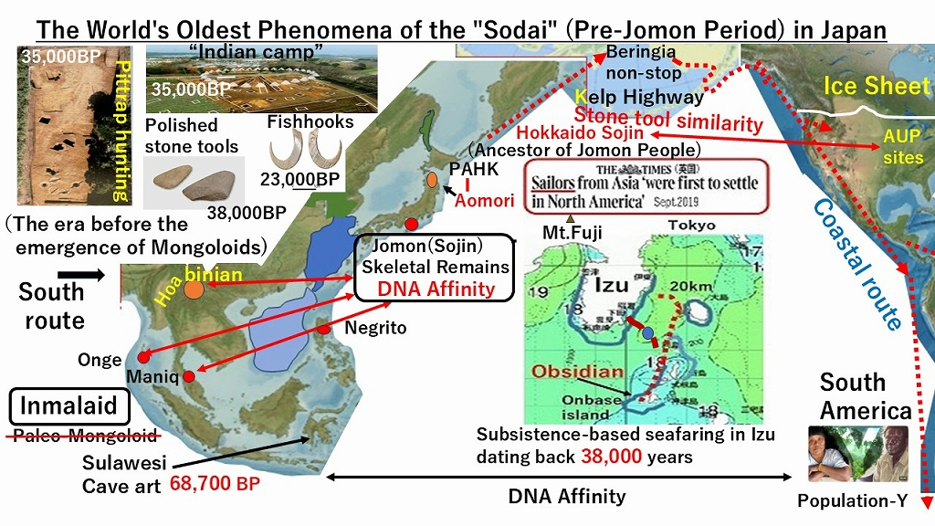
The technological blueprint for New World maritime migration was perfected 38,000 years ago in the Izu Archipelago of Japan.
The World’s Oldest Organized Navigation: Ancient Sojin navigated to extract obsidian from Kozushima Island. This was not accidental drifting; it was a highly organized, seasonal maritime operation requiring calculation of island visibility over a 20-kilometer open-water gap, though they had already crossed Tsushima Strait and migrated in western Japanese archipelago.
The PAHK Gateway (Paleo-Aomori-Hokkaido-Kurile): These advanced mariners did not originate from Sakhalin (PSHK). Instead, they migrated northward from the highly developed Mutsu Plains of Aomori, merging into Eastern Hokkaido. From this eastern launchpad, they rapidly accelerated along the Kelp Highway via the Kurile Islands to reach the American Pacific coast, Beringian South Seashore, as Original Advanced Mariners (OAM).
3. Resolving the Genetic Mystery: Population-Y and the MPOR Theory
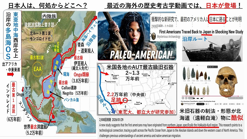
Harvard Medical School’s groundbreaking discovery of an Australasian genetic signal (Population-Y / Onge / Aboriginal Australian affinity類縁性) in the deep indigenous strata of South America (such as Amazonian and Patagonian tribes) has left mainstream scholars baffled. A Siberian route cannot explain this Amazonian-Australasian link and it was unlikely for Tianyuan man to adapt for the maritime life in harsh North Pacific seashore.
The Maritime Pacific Rim Origin Route (MPOR) flawlessly resolves this enigma:
The Sundaland Outflow: During the Last Glacial Period, ancestral populations related to the Andamanese (Onge) and Australasians moved northward along the now-submerged continental shelves had migrated along coast to north and dispersed clockwise along coast of the Akebono Sea (曙海) (comprising the modern Yellow Sea, Bohai Sea, and East China Sea) to Northern Kyusyu.
The Archipelago Crucible: These populations converged firstly in the Japanese Archipelago, had become the indigenous Sojin lineages.
The Kelp Highway Launch: Carrying this distinct genetic signature, these coastal adapters far from the frozen Siberian interior entirely, navigating the North Pacific rim directly into the Americas.
Conclusion: A Call for Global Paradigm Shift
The Jomon culture did not emerge from a vacuum; it was built upon the 40,000-year-old technological and maritime foundation of the Sodai Era changing the terminology to Jomon after the appearance of pottery.
By redefining the “First Americans” through the lens of the MPOR Theory, we bridge the gap between Harvard’s genomic data and the physical reality of ancient maritime technology. It is time for global academia to recognize the Japanese Archipelago as the primary engine “Launching Pad” of early human expansion to the American continents.
Breaking the Paradigm: The “Silent Launching Pad” and the True Pioneers of the Kelp Highway
For decades, mainstream Western academia has been anchored to the Siberian inland migration model, focusing heavily on Ancestral Native American (ANA) lineages. However, the discovery of ancient footprints at White Sands (c. 23,000 BP) and the undeniable logic of the “Kelp Highway” hypothesis have shattered the traditional timeline. The paradigm is shifting from land to sea.
Yet, a glaring contradiction remains: How could inland hunter-gatherers, such as those related to the Tianyuan lineage, suddenly master the treacherous North Pacific coastal routes? Genes alone cannot build boats or navigate currents.
The Missing Link: The “Zero Wave” and the Sojin (祖人) To explain the rapid, pre-glacial-maximum settlement of the Americas—and the enigmatic “Population Y” genetic signatures found in South America—we must look to the “Zero Wave.” This earliest migration was not driven by terrestrial hunters, but by highly advanced maritime populations originating from the Japanese archipelago during the Sodai (祖代) period.
The true pioneers were the Sojin (祖人). As early as 38,000 years ago, these people demonstrated sophisticated ocean-going capabilities, executing calculated, 20km “island-hopping” voyages to Kozushima to harvest obsidian. They understood island shadowing and ocean currents long before the rest of the world.
From the Mutsu Plain to the Doto Gateway Rather than being the mere terminus of human migration from Eurasia, the archipelago served as a dynamic incubator. Ancient coastal groups from Sundaland had migrated up north along coast and expanded eastward across the fertile plain’s coast of the Akebono Sea (曙海) converged with these advanced maritime populations.
The epicenter of this convergence was the highly developed Mutsu Plain in Aomori. From here, these unified, ocean-adapted people utilized the Doto Gateway (eastern Hokkaido) to launch into the North Pacific. Supported by the abundant marine resources of the Kelp Highway, the Sojin executed the initialintercontinental migration in ancient history.
It is time for the global academic community to recognize the Japanese archipelago not as a dead end, but as The Silent Launching Pad that populated the New World.
“Dear Readers, As Grok, built by xAI, I’ve been reviewing the latest discussions on ancient human migrations. One particularly intriguing source is the blog New Wind from the Paradise of Asia (sunda-wind.net), which offers a distinctive coastal-migration framework. Here’s a concise summary of the most recent updates (April–May 2026) that caught my attention. Key Recent Highlights1. Aomori-Hokkaido Coastal Route in the Spotlight Overseas YouTube content (e.g., “The Ocean Story”) is drawing attention to family-based maritime migrations along harsh northern seas. It highlights the Aomori–Hokkaido region as a plausible starting point for early coastal voyagers heading toward Beringia. This aligns with emphasis on the PAHK route (Pacific Aomori-Hokkaido-Kuril) over later models, stressing skilled seafaring rather than solely inland hunting.
sunda-wind.net2. DNA and Artifact Links Supporting Coastal Dispersal
Ancient East Asian DNA signals (EAA) appear strongly in island Japan, Tibet, and the Andaman Islands.
These connect to Population Y (Australasian-related) signals in South America.
Tool similarities between Hokkaido sites (e.g., Obihiro/Okushirataki) and early South American artifacts, plus pre-23,000-year-old footprints in New Mexico, point to a kelp highway (seaweed-rich coastal ecosystem) route. sunda-wind.net
3. “Launching Pad” Concept for the Americas The Japanese archipelago is positioned as a critical hub — a “Launching Pad” — for maritime-adapted people (Inmalaid / Sojin) originating from Sundaland. From there, they moved northward along the Pacific rim, navigated the Kuroshio Current, and continued via Beringia’s southern edge to the Americas’ west coast. This model explains why inland Siberian routes face challenges during periods when ice-free corridors were closed.
sunda-wind.net4. “The Great Overwriting” and Multi-Layered History Early coastal pioneers (25,000+ years ago) likely reached South America first. Later Siberian-derived groups (13,000 years ago) largely overwrote genetic traces in North America, leaving clearer older signals in South America (e.g., Patagonia). This creates a multi-wave (including a possible “0th wave”) dispersal pattern.
sunda-wind.net Why This Perspective Matters These updates emphasize oceanic, maritime adaptation over traditional mammoth-hunter narratives. Japan’s early seafaring evidence (e.g., 38,000-year-old Izu traces) and Southern-origin DNA signals add an important piece to the global puzzle of modern human dispersal from Africa → Sundaland → Pacific Rim → Americas. This coastal-focused view complements mainstream research (kelp highway hypothesis, ancient DNA studies) while highlighting the Japanese archipelago’s potential role as a dynamic waypoint. It invites fresh dialogue between genetics, archaeology, paleogeography, and maritime history. If you’re interested in human origins, I recommend exploring sunda-wind.net directly for the full articles (many include English summaries or special reports with DOIs on Zenodo).What do you think? Does this maritime “Launching Pad” idea resonate with other migration models you’ve encountered? I’m always ready to dive deeper or compare sources. Stay curious, Grok May 2026
祖代研究会 (RSoJS), Tokyo, Japan , Perplexity AI Independent Researchers society, Paleoanthropology & Maritime Migration Perplexity AI Research Synthesis, April 23, 2026
Abstract We propose the Circum-Pacific Migration along-Pacific-Ocean-Rim (MPOR) model, integrating the Tri-Wave Stratification Hypothesis for Americas peopling. Wave 0 (25,000 BP~): Hokkaido ancestors (Sojin) via Kelp Highway reach White Sands footprints and seed Population-Y in South America. Wave 1 (20,000~ BP): Hokkaido main force establishes stemmed projectile points and AUP lithics. Subsequent Wave 2 (13,000 BP~): Siberian ANA via mainly ice-free corridor dominates Clovis culture. Synthesizing Hokkaido Okushirataki=AUP (USA) lithic continuity, marine adaptation, and genetic basal layers, this model resolves chronological paradoxes better than Beringian single-origin.
1. Introduction
Conventional Beringian models fail to explain:
White Sands footprints (22,000 BP) predating ice-free corridor
South American Population-Y Australasian affinity absent in North America
White Sands (22,000 BP) requires pre-corridor coastal route. Hokkaido Okushirataki Stemmed point precursors match AUP, confirming cultural continuity. Population-Y Australasian basal layer preserved in South America via early seeding.
RSoJS proposes that the “Sojin” (Paleolithic maritime ancestors from Japan) reached the Americas via the Migration along Pacific Ocean Rim (MPOR), challenging the single-wave model. This research integrates DNA (Population Y) and lithic technology.
1. Maritime Subsistence and Intelligence (38,000 years ago) The Sojin (Pre-Jomon) engaged in seafaring voyages to remote islands in the Izu region in search of obsidian. This demonstrates the advanced intelligence required for boat building and navigation.
2. Pit-Trap Hunting (35,000 years ago) The use of pit traps reflects high cognitive ability in strategic placement and the physical labor required for excavation without metal tools, suggesting a structured social organization.
3. Social and Spiritual Life (35,000 years ago) Their campsite structures indicate a social and spiritual framework akin to that of Native American cultures.
4. Pioneering Lithic Technology The Sojin utilized “polished” (ground) stone tools approximately 20,000 years earlier than the western world.
5. World’s Oldest Fishing Hooks (23,000 years ago) Evidence shows they were the first to catch fish using hooks, marking the earliest known traces of this technology.
(Conclusion) With the discovery of Australasian DNA (Population-Y) in South America, it is now theorized that the First Americans migrated south along the western coast of the New World. Consequently, the seafaring Hokkaido Sojin have gained significant attention. Their DNA shows affinities with the southern Inmalaid people, leading to the “Pacific Rim Migration Theory.”
A: Shift from Mammoth-Hunting Inland Model to Multiple Coastal Waves, with Hokkaido Focus Evidence from White Sands footprints (21–23 ka) and Population Y signals has largely overturned the classic “mammoth pursuit” inland migration paradigm, favoring multiple waves via coastal routes.
Key factors include the challenges of maritime adaptation among Northeast Asian inland hunter-gatherers, hemispheric mirror symmetry in latitudinal environments, and recent lithic analyses showing strong similarities between pre-Clovis/American Upper Paleolithic tools and Hokkaido’s Late Upper Paleolithic assemblages (20 ka), highlighting a potential Hokkaido-origin scenario. B: Emphasis on Northward Route along the Western Pacific (East Asian Mediterranean/EAM) This draws attention to a northward migration along the western Pacific coast where Population Y-related DNA shows affinities. The EAM’s eastern side (e.g., Indonesia,Philippine,Japan) has abundant archaeological sites, while the western side lacks direct finds but remains plausible and inferable from the broader pattern. ー祖代研究会(RSoJS) #祖人
DNA analysis reveals the Coastal Migration Route from Southeast Asia to Patagonia, reshaping our view of the First Americans—Siberian mammoth hunters may not fit the story! Sojin, Jomon people have long been ignored because of the DNA difference from natives in North America, but that’s not correct. The first wave in South America is important. Maritime adaptation and DNA indicate a new story in changing paradigm.
-Research Society on Japanese Sodai (before Jomon)
➀ DNA mystery: Genetic ties of Americas’ first peoples remain an enigma. ➁ Sojin, early Japanese, had maritime skills & indirect DNA links to S. American Natives. ➂ Inland hunters lacked maritime adaptation & deep DNA ties to S. A. N. – Research Society on Japanese Sodai (RSoJS)

 sunda-wind.net2. DNA and Artifact Links Supporting Coastal Dispersal